Tropical cyclone Freddy hits Madagascar and Mozambique
Tropical Cyclone Freddy, one of the longest-lasting systems in the southern hemisphere, hit Madagascar with strong winds and high seas and threatens Mozambique and neighbouring parts of southern Africa with dangerous and exceptional rainfall levels. Accurate early warnings and early action on the ground helped limit loss of life in Madagascar, with initial reports of 7 casualties, underlining the importance of the UN’s ongoing Early Warnings for All campaign.

After picking up energy and moisture over the Mozambique Channel, Freddy is expected to make landfall in Mozambique as a severe tropical storm on Friday 24 between Beira and Inhambane.
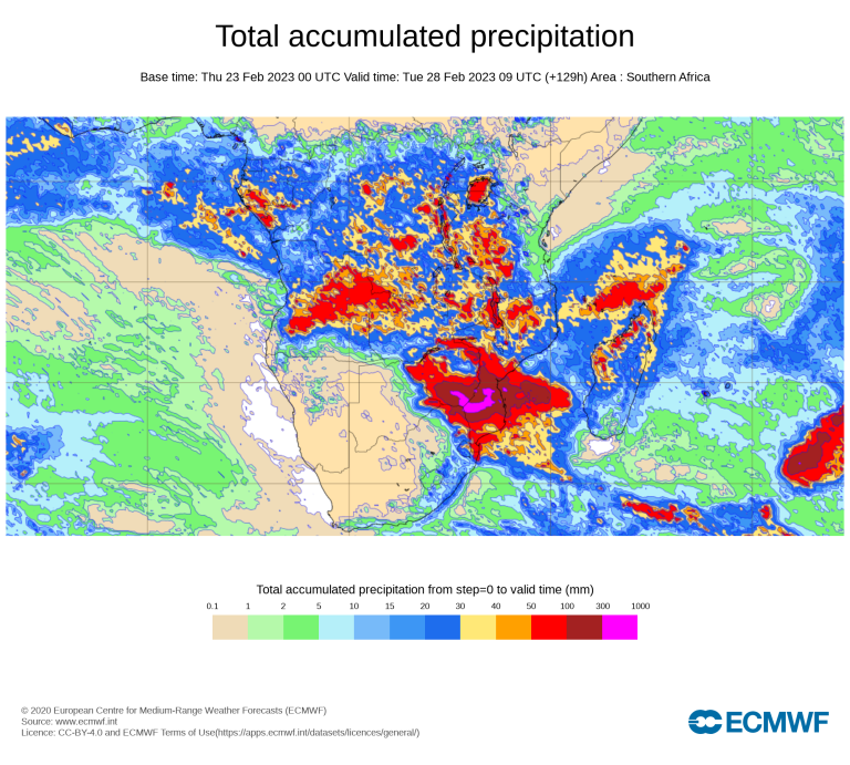
There is a potential risk that months worth of rainfall may fall in the space of a few days, causing widespread flooding in an area which already has saturated soils and high river basin levels from unusually heavy seasonal rains.

Mozambique and its national meteorological service INAM declared a red alert in order to accelerate response operations.
The Office for the Coordination of Humanitarian Affairs (OCHA) warned that “the confluence of multiple threats is compounding a severe humanitarian situation in Mozambique."
Mozambique’s National Insitute for Disaster Management estimates that flooding in central and southern Mozambique – including following Cyclone Freddy’s landfall – might affect up to 1.75 million people.
WMO’s Regional Specialized Meteorological Centre La Réunion (Meteo-France) said that in the next 72 hours:
- There will be hurricane force winds likely during friday morning until early afternoon.
- Heavy seas (6 to 9 meters) near the landfall area on friday morning and noon.
- Intense rainfall South of Beira, notably in inhambane province, rapidly spreading inland (gaza province) with accumulations exceeding 200 to 300 mm and locally 400 mm in 72 hours.
South/southeastern Zimbabwe (and possibly extreme Northeastern South Africa) may receive intense rainfall from Saturday exceeding 100-200 mm in 24 hours and locally 300 mm in 48 hours, which may cause severe flooding.
The South African Weather Service warned of “widespread significant flooding. » with potentially “catastrophic and prolonged and severe impacts. »
This comes after significant flooding occurred in northern South Africa in the last few weeks, including the famed Kruger National Park.
Madagascar
Freddy developed on 6 February off the coast of north-west of Australia and affected island nations, including Mauritius and La Réunion, during its long journey across the entire South Indian Ocean. This kind of super zonal track is very rare. The most recent recorded cases were Tropical Cyclones Leon-Eline and Hudah, both in 2000, which like 2023 was a la Niña year.
Freddy weakened from an intense category 4 equivalent (on the Saffir Simpson scale) into a category 3 cyclone ahead of landfall on the eastern Malagasy coast near the town of Mananjary in the evening of 21 February with sustained windspeeds of 150 km/h . This was the same region which was hit in February 2022 by tropical cyclones Batsirai and Emnati – two of five tropical cyclones which caused devastation and loss of life in Madagascar last year.
Madagascar’s National Meteorological and Hydrological Service issued regular warnings and advisories to the population, backed up by forecasts guidance from WMO’s regional specialized meteorological centre La Réunion (Météo-France). The National Risk and Disaster Management Office said there were seven deaths, according to initial reports, and more than 78 000 people affected.
Tropical Cyclone Freddy was less intense and more compact than Batsirai one year ago and so its impact was smaller. But, most importantly, early warnings led to effective early action. Mass evacuations from the sea shore helped limit loss of life.
Madagascar is one of many developing countries which are targeted by the UN Initiative to ensure that everyone is protected by early warning systems in the next five years.
Background
Mozambique is unfortunately regularly hit by the impacts of tropical cyclones – and flooding often poses a greater risk than the winds.
In January 2021, Tropical Cyclone Eloise caused widespread damage and flooding on a long swathe of coastline and impacted an area still recovering from Cyclone Idai (March 2019).
In both the cases of Eloise and Idai, flooding had impacts not just on Mozambique but on neighbouring countries – Zimbababwe, Malawi and parts of South Africa.
And this will also be the case with Freddy.

