WMO certifies two megaflash lightning records
Geneva, 1st February 2022 (WMO) - The World Meteorological Organization (WMO) has established two new world records for megaflashes of lightning in notorious hotspots in North and South America.

Geneva, 1st February 2022 (WMO) - The World Meteorological Organization (WMO) has established two new world records for megaflashes of lightning in notorious hotspots in North and South America.
Aided by the latest satellite technology, WMO’s Committee on Weather and Climate Extremes, which maintains official records of global, hemispheric and regional extremes recognized:
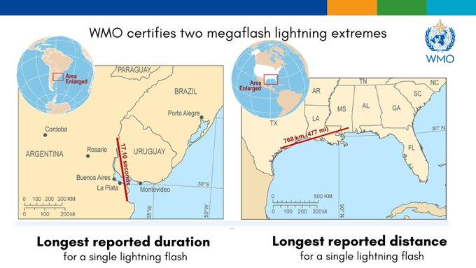
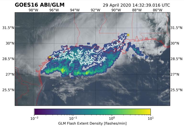
- The longest single flash that covered a horizontal distance of 768 ± 8 km (477.2 ± 5 miles) across parts of the southern United States on 29 April 2020. This is equivalent to the distance between New York City and Columbus Ohio in the United States or between London and the German city of Hamburg.
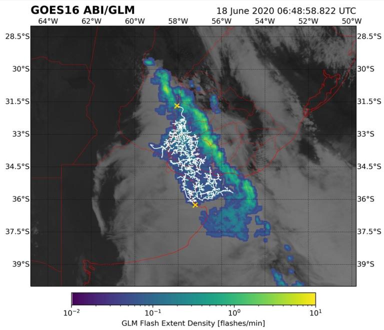
- The greatest duration for a single lightning flash of 17.102 ± 0.002 seconds from the flash that developed continuously through a thunderstorm over Uruguay and northern Argentina on 18 June 2020.

The new record for the longest detected megaflash distance is 60 kilometres more than the previous record, with a distance of 709 ± 8 km (440.6 ± 5 mi) across parts of southern Brazil on 31 October 2018. Both the previous and new record used the same maximum great circle distance methodology to measure flash extent.
The longest duration megaflash had a previous duration of 16.73 seconds which was derived from a flash that developed continuously over northern Argentina on 4 March 2019, 0.37 seconds shorter than the new record.
The findings were published in the Bulletin of the American Meteorological Society.
“These are extraordinary records from single lightning flash events. Environmental extremes are living measurements of the power of nature, as well as scientific progress in being able to make such assessments. It is likely that even greater extremes still exist, and that we will be able to observe them as lightning detection technology improves,” said Professor Randall Cerveny, rapporteur of Weather and Climate Extremes for WMO.
“Lightning is a major hazard that claims many lives every year. The findings highlight important public lightning safety concerns for electrified clouds where flashes can travel extremely large distances,” said WMO Secretary-General Prof. Petteri Taalas.
The new record strikes occurred in hotspots for Mesoscale Convective System (MCS) thunderstorms, whose dynamics permit extraordinary megaflashes to occur – namely, the Great Plains in North America, and the La Plata basin in South America.
Noted lightning specialist and committee member Ron Holle noted, “these extremely large and long-duration lightning events were not isolated but happened during active thunderstorms. Any time there is thunder heard it is time to reach a lightning-safe place.”
The only lightning-safe locations are substantial buildings that have wiring and plumbing; not structures such as at a beach or bus stop. The second reliably safe location is inside a fully enclosed metal-topped vehicle; not dune buggies or motorcycles. If lightning is within 10 km as found with reliable lightning data, go to the lightning safe building or vehicle. As these extreme cases show, lightning can arrive within seconds over a long distance, but they are embedded within larger thunderstorms, so be aware.”
The WMO Archive of Weather and Climate Extremes maintains official records of the world, hemispheric and regional extreme records associated with a number of specific types of weather. Presently, the Archive lists extremes for temperature, pressure, rainfall, hail, wind, and lightning as well as two specific types of storms, tornadoes and tropical cyclones.
Other previously accepted WMO lightning extremes are:
- Direct strike: 21 people killed by a single flash of lightning as they huddled for safety in a hut in Zimbabwe in 1975.
- Indirect strike: 469 people killed in Dronka Egypt when lightning struck a set of oil tanks, causing burning oil to flood the town in 1994.
Space-based technology
The previous assessments that established the flash duration and extent records used data collected by ground-based Lightning Mapping Array (LMA) networks. Many lightning scientists acknowledged that there are upper limits for the scale of lightning that could be observed by any existing LMA. Identifying megaflashes beyond these extremes would require a lightning mapping technology with a larger observation domain.
Recent advances in space-based lightning mapping offer the ability to measure flash extent and duration continuously over broad geospatial domains. These new instruments include the Geostationary Lightning Mappers (GLMs) on the R-series Geostationary Operational Environmental Satellites (GOES-16 and 17) that recorded the new lighting records, and their orbiting counterparts from Europe (the Meteosat Third Generation (MTG) Lightning Imager) and China (FY-4 Lightning Mapping Imager).
"Lightning is a surprisingly elusive and complex natural phenomenon for the impact that it has on our daily lives. We are now at a place where we have excellent measurements of its many facets, which allow us to discover surprising new aspects of its behavior. Now that we have a robust record of these monster flashes, we can begin to understand how they occur and appreciate the disproportionate impact that they have. There is still a lot that we do not know about these monsters, but as an early career scientist, it is a privilege to stand among my colleagues at the forefront of this new and exciting area of research and to push the boundaries of our understanding of what lightning is capable of."” said lead author and evaluation committee member Michael J. Peterson, of the Space and Remote Sensing Group (ISR-2) of Los Alamos National Laboratory, USA.
The space-based instruments will provide near-global coverage of total lightning (both intracloud flashes and cloud-to-ground flashes).
For further information contact:
Clare Nullis, media officer. Email cnullis@wmo.int. Cell +41 79 709 13 97
WMO Weather and Climate Extremes Rapporteur Randall S. Cerveny email:cerveny@asu.edu
The World Meteorological Organization is the United Nations System’s authoritative voice
on Weather, Climate and Water
Notes to Editors
Committee Members (affiliation and countries listed in parenthesis)
Michael J. Peterson (ISR-2, Los Alamos National Laboratory, USA)
Timothy J. Lang (NASA Marshall Space Flight Center, USA)
Timothy Logan (Texas A&M University, College Station, TX USA)
Cheong Wee Kiong (Meteorological Service Singapore, Singapore)
Morne Gijben (South African Weather Service, Pretoria South Africa)
Ron Holle (Holle Meteorology & Photography, Oro Valley, AZ USA)
Ivana Kolmasova (Institute of Atmospheric Physics, Czech Academy of Sciences, Prague Czechia and Charles University, Prague Czechia)
Martino Marisaldi (Department of Physics and Technology, Birkeland Centre for Space Science, University of Bergen, Bergen, Norway)
Joan Montanya (Polytechnic University of Catalonia, Barcelona Spain)
Sunil D. Pawar (Indian Institute of Tropical Meteorology, Pune India)
Daile Zhang (University of Maryland, College Park MD USA)
Manola Brunet (University Rovira i Virgili, Tarragona Spain & University of East Anglia, Norwich UK)
Randall S. Cerveny (Arizona State University, Tempe AZ USA)

Satellite image of record duration of lightning flash over Uruguay and Argentina on 18 June 2020 with a 17.102 s duration. The horizontal structure (white line segments) and maximum extent (gold X symbols) of this megaflash are overlaid.

Satellite image of record extent of lightning flash over the southern United States on 29 April 2020 covered a horizontal distance of 768 ± 8 km (477.2 ± 5 mi). The horizontal structure (white line segments) and maximum extent (gold X symbols) of this megaflash are overlaid.

